Geopedia

Geopedia is a web based application for searching, viewing, and editing of geographical data, with service available to many clients at the same time.

It contains various kinds of geographical and georeferenced information which comes from many different sources and is thoroughly described, tagged, cross-referenced and categorized.
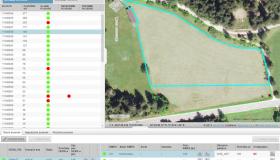
Its user-friendly web interface makes it easy to find items of interest and to display them on interactive maps, which can be saved for later viewing and manipulation. Users can define and publish new layers with custom styling and textual descriptions, aggregate related layers into custom maps and associate them with other sources of information. Its advanced browser-based geometry editor allows anyone to insert new geographical features or edit existing one. Advanced filtering options allow more clean view of mass data.
Find out more about how Geopedia works on Geopedia Portal.
Main features
- Managing of raster layers (topographic maps), vector themes (point, line, polygon)
and points of interests (accommodation, restorations etc.) - Easy panning and zooming
- Resizable sidebar for best user experience
- Support of SVG symbols and import of new symbols
- Numerical and graphical scaling
- Reordering and show-/hide of layers
- Multilanguage
- Advanced filter options
- Preparing of thematic layers
- Layer import and export
- 3D view
- Mobile support
You can employ Geopedia system as:
- Service - the system and the data are situated on Sinergise servers. The application is than integrated into client system, the data come from the host system.
- Product – whole system is situated on other location including data base.
Integrating Geopedia into website
We’ve created Geopedia widget, that can be implemented into other websites (similar to Google Maps). Key advantage is that users can create their own set of layers within Geopedia, group them with other public layers into themes and publish them on their web-site. The integration is simple and supports javascript functions for turning on/off specific layers, setting location, filtering layers etc.