The second Sinergise Summer School!

Are you a student or a young professional interested in learning more about the technologies and tools used to develop modern applications that help us monitor our planet?
Would you like to learn how we use satellite data to do this?
Do you enjoy coding and want to improve your skills?
Would you like your solutions to have a real-world impact?
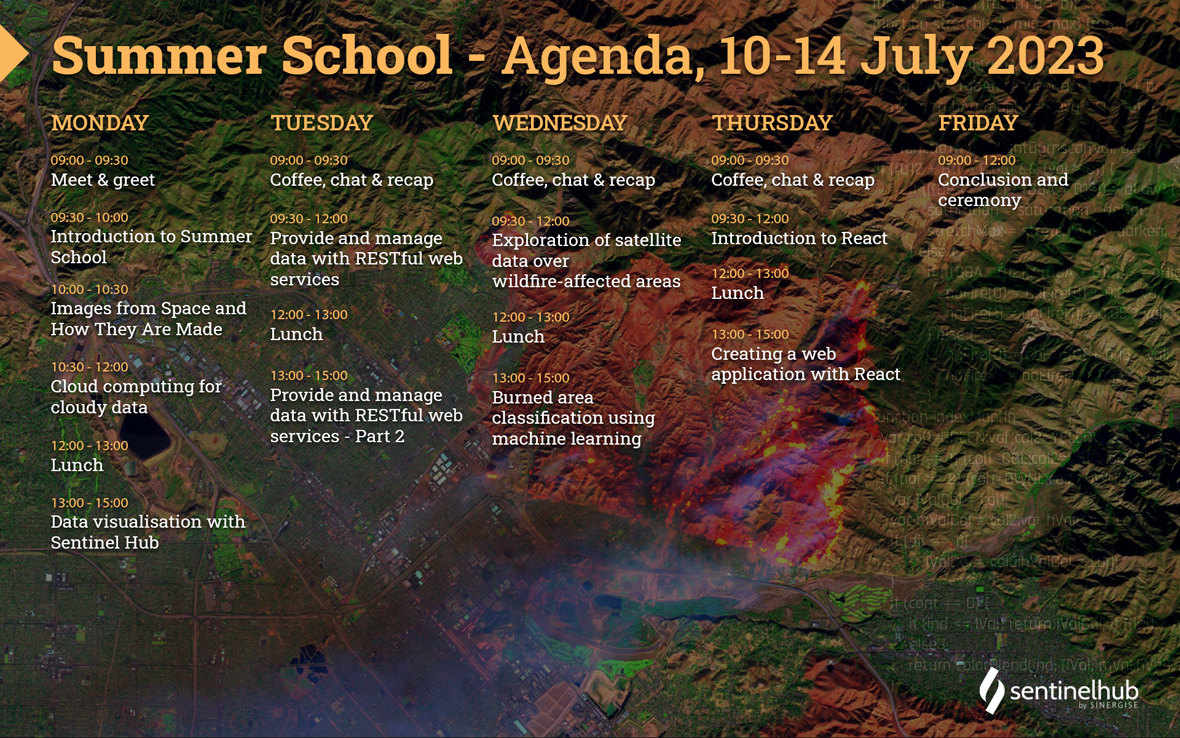
Join our second Summer School, which will take place in person at our headquarters in Ljubljana from 10-14 July 2023.
Why should you attend?
In one week you will learn how to process satellite imagery and save it to an AWS S3 bucket, serve data via REST API, display it in a web application, and apply machine learning algorithms to it. You will work with technologies such as Java / Spring boot, React, and Python.
We will lead you through each of these steps while focusing on a wildfires use-case. You will get a behind-the-scenes look at what we do, how we do it, and how we are doing our part to create a better future for our planet.
Who should attend?
Enthusiasts who want to learn how we leverage satellite imagery to create modern applications. In addition to a basic knowledge of Python, Java or web programming concepts, your willingness to learn will help you get on board.
What can you expect?
A week of interesting hands-on workshops, led by our expert team of engineers and data scientists. The programme will consist of a combination of short introductory lectures followed by practical exercises adapted to the participant's experience and previous knowledge. All the workshops will be in English.
First, we will teach you the basics of satellite imagery, show you how to leverage AWS technologies to handle large amounts of data, and how you can use Sentinel Hub to create custom visualisations for any area of interest. We will talk about satellites, explain basic Earth Observation terms and look at some of the types of data available for analysis.
We will build a small service that runs on AWS Lambda serverless computing cluster, reads requests from a message queue (AWS SQS), downloads the requested data from Sentinel Hub, and stores it into object storage (AWS S3) for further analysis. We will also show you how to use JavaScript on Sentinel Hub to generate the data you need.
After analysing and generating data from the affected areas, we will index them and provide an API for the front end. We will learn how to set up a Spring Boot service with Gradle dependency manager and implement an ETL process where we'll ingest the data to our DB via Hibernate ORM and expose it via a REST API.
Then we will learn how to detect wildfires using satellite imagery and machine learning (ML). You will be given a dataset with real information about areas affected by wildfires and explore the features that can be used to detect such areas in raw data. After gaining a basic understanding of the inputs, we will train a ML model for automatically tagging areas affected by wildfires and convert it into an EvalScript so that it can be used in EO Browser. A visual inspection of the affected areas will give us insight into the performance of the model, where we will see if it is possible to improve it further.
Finally, we will look at how to present satellite data and data from the implemented API. We will create a web application using React that allows us to break the user interface into smaller, more manageable pieces. We will also learn how to create a meaningful chart and an interactive map to display satellite imagery on it.
What do you need?
Our Summer School is completely free of charge! The only things you need to bring are your own computer, your commitment and your enthusiasm! We'll take care of the rest!
Where can I apply?
Registrations are closed!
For more information, email us anytime.
Agenda