See You at the 26th MARS Conference in Barcelona

We look forward to meeting you in person at the 26th MARS conference, which will be held in Barcelona, Spain, from 12 to 14 September. The conference is jointly organised by the Joint Research Centre, the Spanish Paying Agency and the Ministry of Climate Action, Food and Rural Agenda of Catalonia, and brings together professionals from the field of management and control of area-based subsidy schemes. It addresses the technologies, methods and protocols that ensure effectiveness and efficiency in this field.
Join our Activities
Visit our booth at a booth exhibition in a hall adjacent to the conference room. We will be there from Monday to Wednesday. Don't miss our presentations on the second day, Tuesday, 13 September:
- The use of super-resolution data in production of AMS markers (H2020 DIONE project) - The presentation is part of the Pecha Kucha session which starts at 11:30.
- Putting all the puzzles together and how they play along in a real-life scenario - The presentation starts at 15:55 and is part of the 2023+ CAP session.
The draft agenda can be downloaded here.
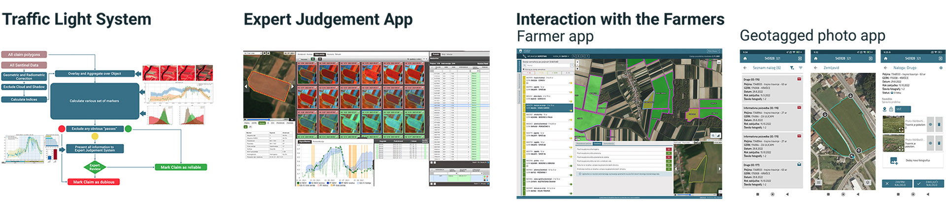
Sinergise and CAP
We have combined our vast experience with CAP applications (LPIS and GSAA), world-leading Sentinel hosting and processing with significant research and development into machine learning and other signal-processing techniques to develop generic area monitoring services applicable across Europe. To learn more about our services, visit our booth and have a chat with us.
Read more about the Area Monitoring in our blog posts, and about the markers:
🔹 Bare-soil
The bare-soil marker identifies all observations with exposed bare soil due to field being recently plowed, or due to non-photosynthetic vegetation cover. Go to blog!
🔹 Homogeneity
The homogeneity marker serves to identify polygons (FOIs) on which several crops are being grown. Go to blog!
🔹 Mowing
Mowing marker identifies all observations where mowing events lead to a drop and subsequent recovery in the time series of vegetation index signal. Go to blog!
🔹 Similarity and Euclidian distance
Markers compare signal time series of a FOI to signal time series of neighboring FOIs. Go to blog!
🔹 Crop and land-use markers
The crop- and land-group markers can be used to determine consistency of a agricultural parcel (FOI) with its declared crop and land-use. Go to blog!
🔹 Binary land-cover marker
Binary land-cover marker is a set of binary land-cover classifiers that are able to give insights into the land-cover of each pixel of a FOI. Go to blog!
🔹 Field delineation
Automatic generation of the contours for agricultural parcels from remote sensing imagery. Go to blog!
About the Conference
This 2022 the Conference is rather special. It takes place very early compared to previous editions to foster some technical discussions before the entry into force of the new CAP legislation in January 2023. For more information, visit the official conference page.