Mobile Field Data Collection
20 Oct 14

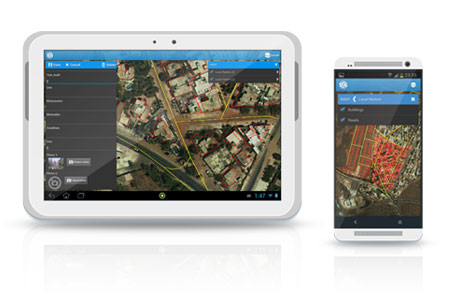
At Sinergise we have developed a field data collection tool for mobile devices. This enables you to collect field data or conduct field surveys easier than ever before.
System includes advanced GIS tools which allow for quick and efficient capturing, editing or displaying of geographic information. It is a cloud based application which further simplifies data collection and most importantly, ensures the highest quality of results.
The Field Data Collection system connects to the data management system and supports the allocation of tasks (packages) amongst surveyors, guided data entry and the seamless transfer of data. This makes it easy for surveyors to access and fill-in their forms anywhere, even offline (when back online the collected data is automatically synced with their geodatabase ).
Main features:
- Viewing and exploring maps in the field.
- On-screen spatial query and measurement tools.
- Editing of spatial features to support digitization of new building outlines, schemes etc.
- Synchronization of data to/from mobile devices for offline use.
- GPS-assisted measurements of field boundaries.
- Use of all available location sensors for data acquisition (GPS position, bearing, inclination).
- Media (photo & audio) enriched location information.
Field Data Collection brochure
We invite you to watch video presentation: