Web GIS viewer

Web GIS viewer is ready for wide use and can be easily and quickly adapt for customer's needs.
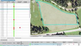
GIS viewer has all needed components - from application server, raster data server (Image server) to user client. It can be linked to Oracle Spatial or MS SQL database.
GIS viewers are customized based on customer's wishes and desires. Customer can edit final product futher on by changing content or layers' look.
Main characteristics/advantages of GIS viewer are:
- does not depend on infrastructure - works on Linux, Windows and other servers
- Oracle Spatial and MS SQL database support
- many vizualization settings for vector layers (color, symbol, shadow, vizualization depending on parameters etc.)
- gazeteer search
- coordinate search, coordinate converter for many coordinate systems
- alpha-numeric data search
- displaying results in table or spatial form (if many results are found)
- easy integration with other web applications - with URL callbacks and database views
- quick response
- multi-language support
- user-friendly interface
- wide browser support (IE7+, Firefox, Chrome, Safari, Opera)
References:
- ETN-JV (customer: GURS)
- ZVN-JV (customer: GURS)
- GERK Web Viewer (customer: MKO)
- ARKOD viewer (customer: APPRRR)
- Visual controls (customer: APPRRR)
- Web Cadastre (customer: Ministry of Housing and Lands)
- VURS viewer (customer: VURS)
Gallery