Geo Toolkit – Data Quality Tools

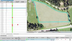
Geo Toolkit is a set of quality data tools. They were developed to provide customers who need to adjust user geographic data in case their existing geographic base layer has changed (e.g. orthophoto base layer). At GIS solutions a lot of users data are snapped to orthophoto base data layer. Whenever a base data layer is improved by reaching a higher precision the user data no longer matches with it.
Geo Toolkit package provides three tools that help users to solve such inadequacies:
- GeoCheck: verifies geo-data validity
- GeoMorph: automated tool for shifting polygons
- GeoClone: tool for checking and adjusting polygons created by GeoMorph
Geo Toolkit advantages:
- Simultaneous processing of a great number of inter-connected data entries
- Time optimization: similar tools require several weeks for the same amount of data, where Geo Toolkit reduces such a procedure to a few hours
- Efficient processing and handling of topological errors in the data